Cenozoic
The Cenozoic era was an important time in the evolution of the Grand Staircase. It represents the last 65 Ma of earth’s history. World famous landforms and geologic features of the Grand Staircase formed during this time. Features such as the colossal Grand Canyon, twisting slot canyons of Zion, and the fascinating hoodoos of Bryce Canyon attract millions of people every year. All of the features are evidence of an incredibly complex Cenozoic history. Regional tectonic, depositional, and erosional forces have played key roles in formation of the spectacular landscape of the Grand Staircase.
Tectonics
During the Mesozoic the Farallon Plate was subducting on the west coast of North America in an eastward orientation. As discussed earlier, this subduction led to a series of orogenies on what is known as the Cordilleran mobile belt. The Nevadan and Sevier orogenies occurred during the Mesozoic as the Farallon Plate subducted at an estimated 45 degrees. The Sevier orogeny led to “thin-skinned” deformation which uplifted and deformed mostly Paleozoic strata. At the end of the Cretaceous the Farallon Plate’s angle of subduction began to flatten out. The low angle subduction of the Farallon plate allowed for deformation to occur further inland. It reactivated many basement faults in what is known as basement cored uplift. This change in deformation marked the beginning of the Laramide Orogeny around 70-80 Ma. This orogeny is famous because it formed the Rocky Mountains which divides North America today. The Laramide orogeny is also responsible for deformation on the Colorado Plateau such as the San Rafael Swell, and the waterpocket fold in Capital Reef National Park. Precambrian faults were also reactivated in the Grand Canyon area to form monoclines such as the East Kaibab monocline.
Around 50 million years ago the Farallon plate began to rollback (Figure 1). This allowed for hot asthenosphere to well up between the down going plate and the continental lithosphere. Heat built up and led to volcanism. The Marysvale volcanic field marks the eastern edge of the volcanism caused by the plate rollback. It was the first in a long chain of volcanoes that erupted throughout the next several million years. As the Farallon plate rolled back it created a chain of volcanoes from central Utah to California.
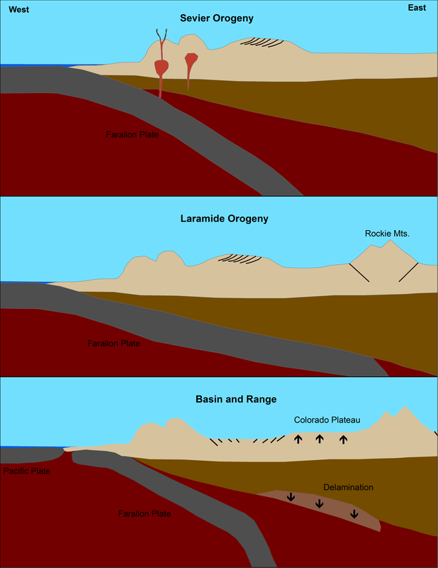
Figure 1. During the Sevier Orogeny the angle of subduction of the Farallon Plate was at about 45 degrees. This created thin-skinned deformation. Around 70-80 Ma the downgoing plate flattened out and led to deformation further to the east known as the Laramide Orogeny. This created thick-skinned deformation known as basement cored uplift. Beginning around 17 Ma slab rollback led to increased volcanism and the extension that formed the Basin and Range Province (Smith, 2016).
The Marysvale volcanic field began erupting around 32 Ma. As magma welled up beneath the volcanic field it led to deformation on its flanks. The Rubys Inn thrust fault in Bryce Canyon National Park is an example of deformation caused by the Marysvale Volcanic Field (Figure 2). The fault dips north and its strike is oriented east – west. Many of the hoodoos at Bryce Canyon also have conjugate fractures (Figure 3). The Rubys Inn thrust fault and the congjgate fractures in Bryce Canyon correlate with north – south orientation of maximum compression caused by the volcanism in the Marysvale Volcanic Field.
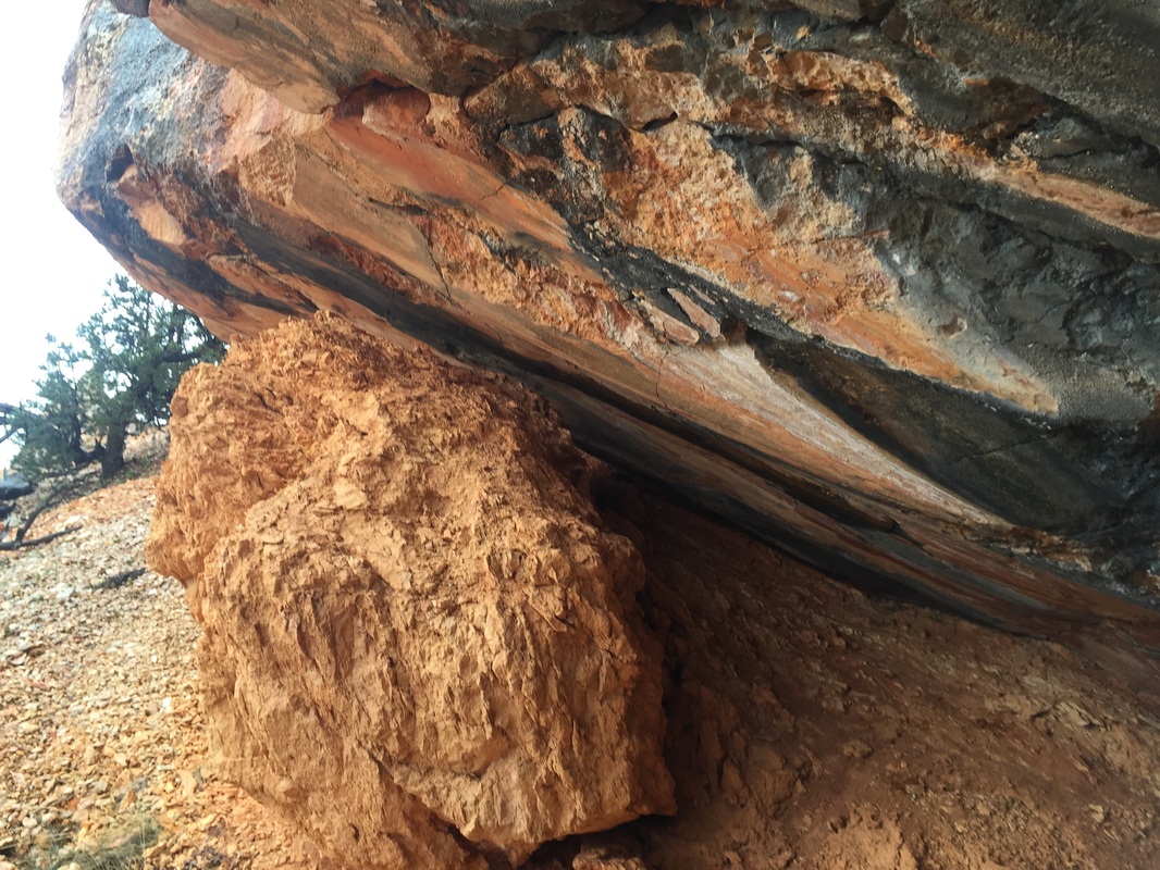
Figure 2. Rubys Inn thrust fault. Hanging wall (top) has distinct slicken sides and lines.
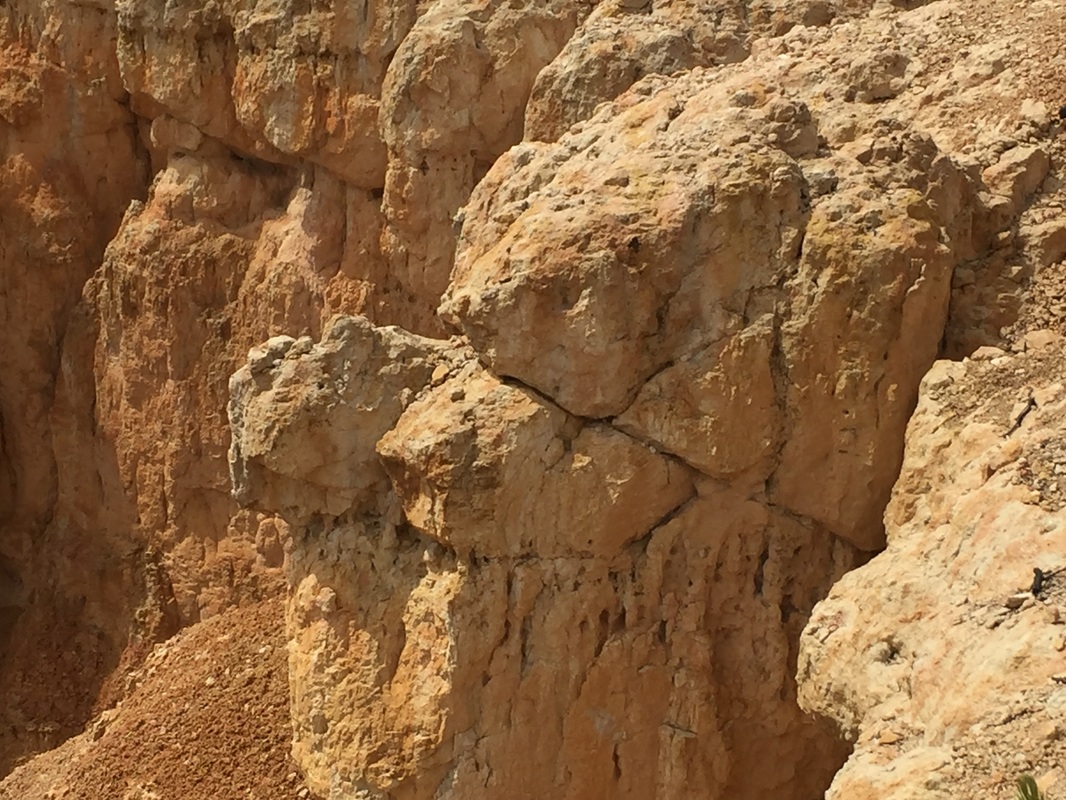
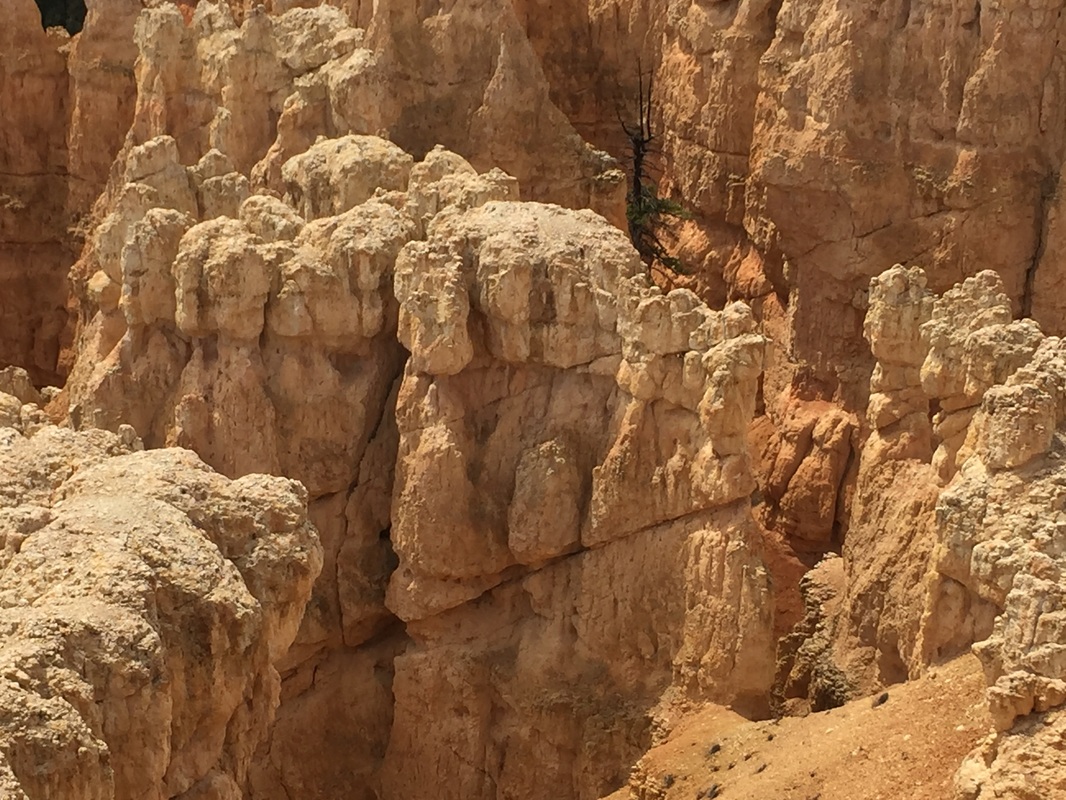
Figure 3. Conjugate Fractures in Bryce Canyon. They represent accommodation from the deformation in the footwall of the Rubys Inn thrust fault.
Volcanism from the Marysvale Volcanic field is also believed to have caused the Markagunt Gravity Slide (MGS) around 22–21 Ma (Hacker, Biek, Rowley, 2014). The full extent of the gravity slide is not fully known but is believed to be about 360 square miles and may have been as large as 500 square miles. The MGS is composed of volcanic mudflow breccias, sandstones, and intertongued regional ash-flow tuffs (Hacker, Biek, Rowley, 2014). The gravity slide moved >30 km from its source. Friction heated the base and possibly other slide planes to melting point and produced a layer pseudotachylite (Figure 4, 5).
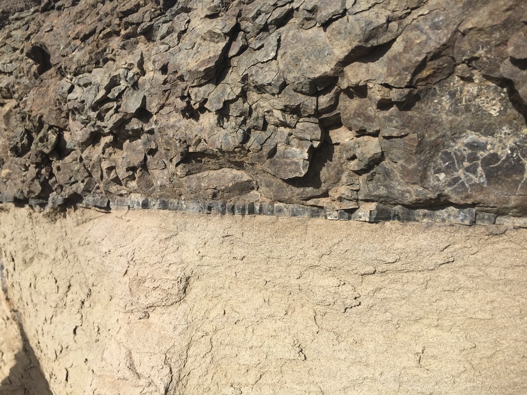
Figure 4. Pseudotachylite in between Bear Valley Formation (Lower Unit) and Mt. Dutton Formation (Upper Unit).
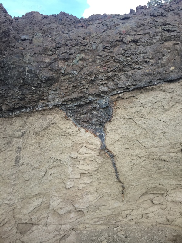
Figure 5. Pseudotachylite vein cuts sandstone of the Bear Valley Formation.
Rollback of the Farallon Plate is believed to have eventually led to extension of the Basin and Range Province beginning around 17 Ma. The boundary between the Basin and Range and the Colorado Plateau are a series of normal faults such as the Hurricane, Sevier, Pausaungunt faults. These faults are roughly parallel to the I-15 corridor in Utah. The Basin and Range Province is an extensional basin that gets its name for the large up thrown fault blocks that form ranges and down thrown fault blocks that form basins. Theses ranges and basins run north and south and give the province a distinct look. The Colorado Plateau is a large area of relatively undeformed sedimentary rocks that have been uplifted and now eroded. Thick layers of sedimentary rock give the Colorado Plateau a layer cake look. Theories about the mechanism for the uplift of the Colorado Plateau are controversial but one theory suggest that delamination of the lithosphere beneath the Colorado Plateau could have led to uplift (Figure 1).
Deposition during the Cenozoic
During the Cretaceous Period the Sevier orogeny formed highlands to the west of what is now the Colorado Plateau. Sediment from these highlands was eroded and deposited in the Interior Cretaceous Seaway. Towards the end of the Cretaceous and beginning of the Paleocene this sea began to regress. The Laramide orogeny caused deformation further east than the Sevier which trapped water and led to the formation of large lakes. One of the most famous lakes during this time was Lake Claron. This lake deposited layers of silt rich limestone during the Paleocene and Eocene (Figure 6,7). At times the lake’s water level would drop enough for soils to form and for fluvial deposits to form on its banks. These deposits were later covered with more limestone when the lake rose. Manganese, limonite, and hematite are common in beds where paleosols have been preserved.
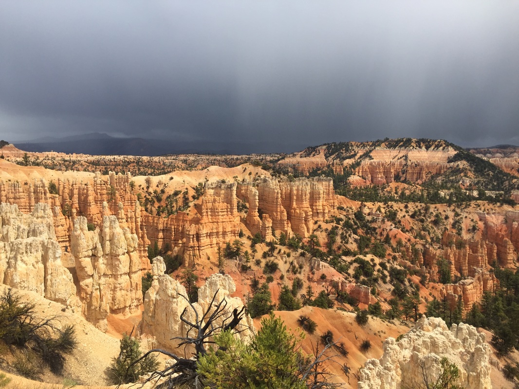
Figure 6. Bright orange, pink, and white layers of the Claron Formation consist of silt rich limestone’s, conglomerates, and paleosols. The Claron Formation has now been highly weathered and eroded to form large amphitheaters with numerous hoodoos.
As the Basin and Range Province has evolved, large north – south trending normal faults have formed. These normal faults have left high plateaus or cuestas in the southern Utah area. These include the Markagunt Plateau, Paunsaugunt Plateau, and the Aquarius Plateau and their associated faults such as the Hurricane, Sevier, and Paunsaugunt (Figure 7).
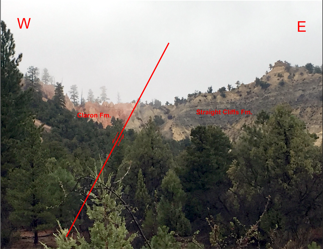
Figure 7. Paunsaugunt Normal Fault. Down dropped fault block is on the right and consists of Claron Formation at the surface. The up thrown fault block is on the left and consist of the Straight Cliffs Formation at the Surface.
Weathering of the sedimentary layers of the Grand Staircase has left these rocks vulnerable to erosion. As these rocks undergo uplift rivers such as the Colorado, Virgin, and Paria have cut deep canyons and carried away massive amounts of sediment (Figure 8,9). Bryce Canyon is the headwaters of the Paria River and has formed a spectacular amphitheater. It lies at a high elevation and during many months of the years is susceptible to frost wedging. Water percolates into Claron formation which freezes and expands at night and thaws during the day forming joints. This process has continued for millions of years and has now formed spectacular hoodoos in the Claron Formation.
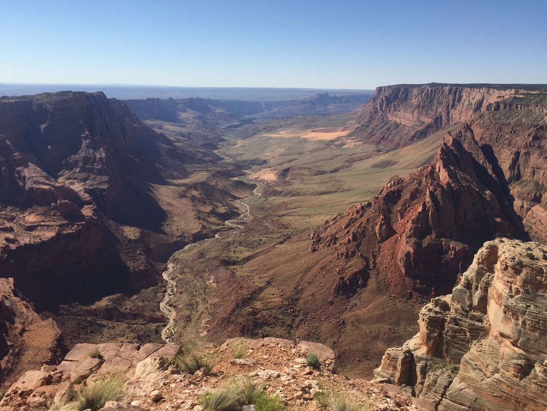
Figure 8. Paria overlook. Vermilion Cliffs National Monument.
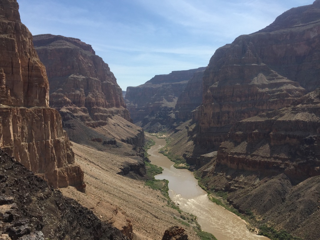
Figure 9. Whitmore Canyon overlook of the Grand Canyon. Grand Canyon National Park.
